Genuine Ukho Now Available
Your lifestyle upgrade starts here—shop our exclusive Ukho collections.
UKHO BA Chart 2193: Punta San Juan to Punta Macolla Including Bonaire- Curacao and Aruba
UKHO BA Chart 1892: Dover Strait Western Part
UKHO BA Chart 142: Strait of Gibraltar
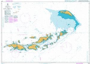
UKHO BA Chart 2006: West Indies, Virgin Islands, Anegada to Saint Thomas
BA Chart 4012: North Atlantic Ocean Southern Part
UKHO BA Chart 4001: A Planning Chart for The Atlantic and Indian Oceans
UKHO BA Chart 4061: South Pacific Ocean, Western Portion
UKHO BA Chart 2865: Cape Romain to Cape Canaveral
UKHO BA Chart 4061: South Pacific Ocean, Western Portion
The Georectification of the UKHO Admiralty Chart 5080 of Lough Derg
The Georectification of the UKHO Admiralty Chart 5080 of Lough Derg
BA Chart 4007: A Planning Chart for the South Pacific Ocean
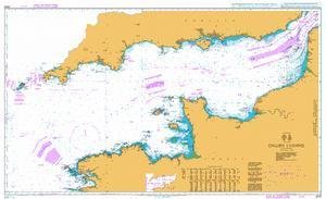
BA Chart 2675: English Channel
UKHO BA Chart 142: Strait of Gibraltar
UKHO BA Chart 2019: British Virgin Islands, North Sound to Road Harbour
UKHO BA Chart 1777: Port of Cork Lower Harbour and Approaches
BA Chart 472: British Admiralty Nautical Chart 472: West Indies, Dominican Republic and Puerto Rico, Mona Passage
The Georectification of the UKHO Admiralty Chart 5080 of Lough Derg
BA Chart 4402: North Atlantic Ocean, Caribbean Sea
UKHO BA Chart 2019: British Virgin Islands, North Sound to Road Harbour
BA Chart 3200: Falkland Islands to South Sandwich Islands and Graham Land
UKHO BA Chart 1892: Dover Strait Western Part
UKHO BA Chart 4958: Canada, British Columbia/Colombie-Britannique, Vancouver Island/ÃŽle de Vancouver, Nanaimo Harbour and/et Departure Bay
UKHO BA Chart 4052: North Pacific Ocean Southwestern Part
Slomannoe Ukho. Prikljuchenija Tintina
UKHO BA Chart 4002: A Planning Chart for The Pacific Ocean
UKHOBA Chart 489: Approaches to Nevis
BA Chart 4907: Approaches to the Antarctic Peninsula
UKHOBA Chart 1385: Cotonou to Pennington River
UKHOBA Chart 983: Subic Bay
UKHOBA Chart 2434: Colombia – North Coast, Bahía de Cartagena
BA Chart 4015: A Planning Chart for the Atlantic Ocean
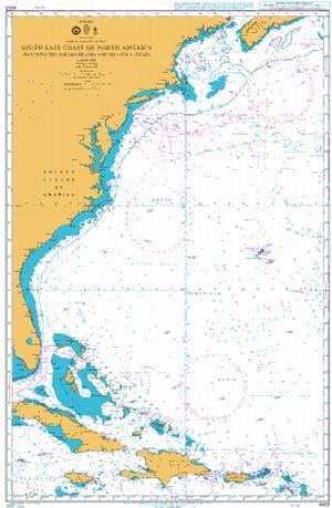
UKHOBA Chart 4403: South East Coast of North America Including The Bahama Islands and Greater Antilles
UKHO BA Chart 4011: North Atlantic Ocean Northern Part
UKHOBA Chart 4140: North Sea
UKHOBA Chart 4005: A Planning Chart for The Indian Ocean
UKHOBA Chart 3339: Approaches to Galway Bay Including The Aran Islands
UKHO BA Chart 3739: Jebel Ali (Mina' Jabal `Ali) and Approaches
BA Chart 4400: The West Indies
UKHOBA Chart 2537: Ghawdex (Gozo)- Kemmuna (Comino) and The Northern Part of Malta
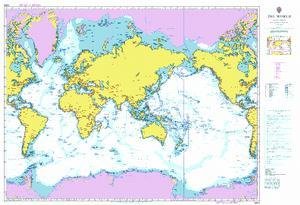
UKHOBA Chart 4000: The World
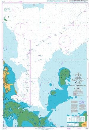
UKHO BA Chart 3738: Outer Approaches to Bahrain
UKHOBA Chart 4212: Drake Passage
UKHO BA Chart 3118: Lagos to Gamba
UKHO BA Chart 4003: A Planning Chart for The South Atlantic Ocean
UKHOBA Chart 793: The Grenadines - Northern Part
UKHOBA Chart 868: Bermuda, Eastern and Western Approaches to The Narrows Including Murray`s Anchorage
UKHOBA Chart 4943: Nootka Sound to/a Quatsino Sound
UKHO BA Chart 2096: Cashla Bay to Kilkieran Bay
Understanding a Nautical Chart: A Practical Guide to Safe Navigation
UKHOBA Chart 791: Saint Vincent to Bequia
BA Chart 2858: Gulf of Oman to Shatt al `Arab
BA Chart 4604: South Pacific Ocean, Coral and Solomon Seas and Adjacent Seas
UKHO BA Chart 2865: Cape Romain to Cape Canaveral