Timeless Dir Maos Classics Reimagined
From timeless classics to modern breakthroughs—discover what Dir Maos has in store.
The Peak District: Dark Peak Area Map | Peak District National Park | Ordnance Survey | OS Explorer Map OL 01 | England | Walks | Hiking | Maps | Adventure
Map : Dir, Swat & Chitral Agency, N.W. Frontier Province, No. 43 A/N.W. 1933, India and Adjacent Countries, Antique Vintage Reproduction : 31in x 44in
Die Berge Sind in Dir: Notizbuch / Notizheft Für Wandern Berg-Wandern Bergsteigen Klettern Outdoor Trekking Camping A5 (6x9in) Dotted Punktraster
Atlas historique du rhin supérieur/der oberrhein: ein historischer atlas : ess: ESSAI D HISTOIRE TRANSFRONTALIERE ? VERSUCH EINER GRENZUBERSCHREITENDEN GESCHICH
Collins Children’s World Wall Map: An illustrated poster for your wall: 12 (Collins Children's Poster)
History of Britain in Maps: Over 90 Maps of our nation through time Hardcover – 2 Nov. 2017
Ordnance SurveyChichester & the South Downs Map | Bognor Regis & Arundel | Ordnance Survey | OS Landranger Map 197 | England | Walks | Cycling | Days Out | Maps | Adventure
World Political Marco Polo Wall Map
Was mein Herz dir sagen will: Liebesroman (German Edition)
Historic Map : Dir Swat & Chitral, Pehsawar District and Tribal Territory, N.W. Frontier Province, No. 43 B/N.W. 1921, India and Adjacent Countries, Antique Vintage Reproduction : 31in x 44in
Ravensburger Kinderpuzzle - 12840 Schnapp sie dir alle! - Pokémon-Puzzle für Kinder ab 8 Jahren, mit 200 Teilen im XXL-Format
Map : Dir District, Pakistan 2004, Upper & Lower Dir Districts, Antique Vintage Reproduction : 44in x 39in
Arundel & Pulborough Map | Worthing & Bognor Regis | Ordnance Survey | OS Explorer Map OL10 | England | Walks | Hiking | Maps | Adventure
Dinge, die dir keiner über den Jakobsweg sagt: Der etwas andere Pilgerratgeber
Kyrgyzstan: (world mapping project) (Kyrgyzstan (1:700.000)): reiß- und wasserfest (world mapping project)
Maps International - Large World Map – Wall Map Poster With Flags – Laminated - 23 x 33
National Geographic Maps World Classic, Laminated: Wall World Map – Wall Map, 2 August 2012
Historic Map : Dir, Swat & Chitral Agency, Peshawar District and Tribal Territory, N.W. Frontier Province, No. 43 B/N.W. 1932, India and Adjacent Countries, Antique Vintage Reproduction : 44in x 62in
Map : Kohistan, Dir Swat & Chitral, Hazara District & Tribal Territory, Kashmir & Jammu & N.W. Frontier Province, No. 43 B/N.E. 1921, India and Adjacent Countries : 16in x 24in
Great British Place Names Map | Funny Map & Guide | Marvellous Maps | Humour | British Gift | British Geography Map – Folded Map, 19 Nov. 2018
Die Berge Sind in Dir: Notizbuch Für Wandern Berg-Wandern Bergsteigen Klettern Outdoor Trekking Camping
Historic Map : Dir, Swat & Chitral Agency, Peshawar District and Swat Territory, N.W. Frontier Province, No. 43 B/N.W. 1928, India and Adjacent Countries, Antique Vintage Reproduction : 18in x 24in
Brilliant Maps: An Atlas for Curious Minds
India Outline map (100 Nos)| A4 Size Multipurpose map For School/College Assignments/Projects/ Practical Loose Leaf – Folded Map, 1 January 2022
India & World Map ( Both Political & Physical ) & India Constitution Chart | Set Of 5 | Map Size - 70X100 cm | Use For Preparation Of UPSC , SSC , IES , etc Exams. Unknown Binding – 1 January 2020
Exmoor Map | Barnstaple, Lynton, Minehead & Dulverton | Ordnance Survey | OS Explorer Map OL9 | England | Walks | Hiking | Maps | Adventure: OL 09
Divalis Detailed Scratch Off World Map Poster - XL - Black and Gold Scratchable World Map - Glossy, Laminated Travel World Map - Full Accessories Kit - Best Gift Scratch Off Map of The World
DAYONG Scratch Off Word Map, Scratch Off Map with Scratcher and Brush, 82x60CM Scratch Off Travel Poster, Travel Map Wall Art Gift for Outdoor Enthusiasts
Webby Wooden Educational India Political Map States Capital Learning, Board Puzzle for 4, 5, 6, 7, 8 Year Old Kids
The GCHQ Puzzle Book II: 2
Flaggen Der Welt Malbuch: Lerne alle Länder der Welt kennen - Male die Flaggen aller Länder aus, wobei dir Farbführungen helfen. (German Edition)
Die Berge Sind in Dir: Notizbuch / Notizheft Für Wandern Berg-Wandern Bergsteigen Klettern Outdoor Trekking Camping A5 (6x9in) Liniert Mit Linien
Maps International - Giant World Map Mural - Mega-Map Of The World Wallpaper - 91 x 62 - Classic colours
India & World Map ( Both Political & Physical ) with Constitution of India , Indian History , Indian Economy & Geographical Terms Chart | Set Of 8 | Useful for UPSC and other competitive exam preparation | by Hivex Publication
1822 Map Carte de l'Afrique Relief Shown by hachures. Atlas Universel Pl. 31.""Gravée Sous la dir|Historic Antique Vintage Reprint|Ready to Frame
India & World Map ( Both Political & Physical ) with Constitution of India Chart | LAMINATED | SET OF 5 | Useful for UPSC, SSC, IES and other competitive exams
Snowdon / Yr Wyddfa Map | Caernafon | Ordnance Survey | OS Landranger Map 115 | Wales | Walks | Cycling | Days Out | Maps | Adventure
Taunton & Lyme Regis Map | Chard & Bridport | Ordnance Survey | OS Landranger Map 193 | England | Walks | Cycling | Days Out | Maps | Adventure
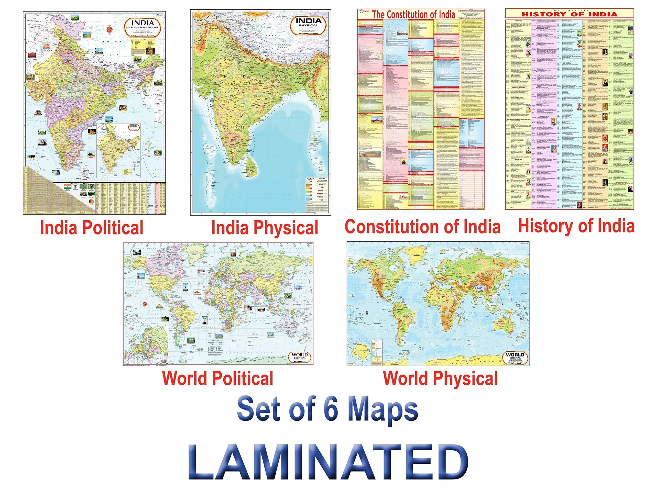
India & World Map ( Both Political & Physical ) with Constitution of India and History of India Chart | LAMINATED SET OF 6 Maps & Charts | Useful for UPSC, SSC, IES and other competitive exams
Great British Map of Wonders | Adventure Map & Guide | Marvellous Maps | Days Out | Holiday Planning | British Geography
STRATA: William Smith’s Geological Maps
Great British Folklore & Superstition Map | Folklore Map & Guide | Marvellous Maps | Mythology | Funny Gift | British Mythology
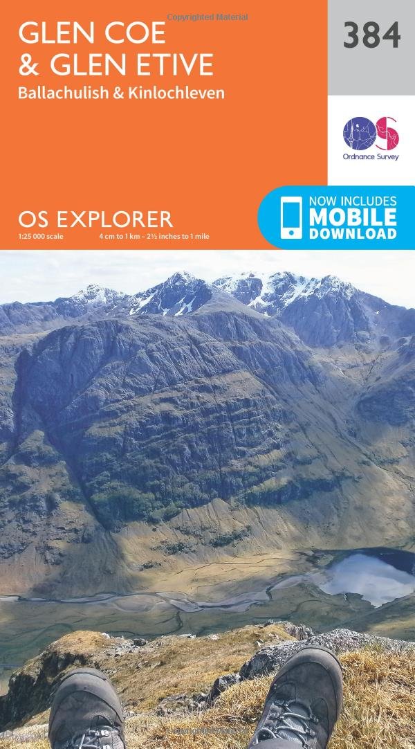
Glen Coe & Glen Etive Map | Ballaculish & Kinlochleven | Ordnance Survey | OS Explorer Map 384 | Scotland | Walks | Hiking | Maps | Adventure
UNIq LATEST 2021 EDITION New Rashtriya School ATLAS WITH USEFUL NOTES - HINDI LANGUAGE. FOR UPSC, IAS AND OTHER ENTRANCE EXAM More than Atlas less than full Encyclopaedia Atlas cum Mini Encyclopaedia
Purbeck & South Dorset Map | Poole, Dorchester, Weymouth & Swanage | Ordnance Survey | OS Explorer Map OL15 | England | Walks | Hiking | Maps | Adventure Map – Folded Map, 10 Jun. 2015
Maps International World Wall Map - Map of The World Poster - Front Lamination - 47 x 33
PROJECT MIND MAPS: Ein hilfreiches Notizbuch zur Erfassung Deiner Projekte und die dazugehörigen Mindmaps (Arbeitsbücher – Mindmaps)
World Map : Political | Laminated Both Sides | 70 x 100 cm ( Big Map )